PDToolKit offers a comprehensive tool to handle the evaluation for precipitous terrain characteristics according to the FAA recommendations. This involves many components for the analysis and results to be presented. Terrain Data – Terrain data is the starting point and this is normally provided by the client but there are many terrain sources available also. Terrain data is available in many different industry formats which ASD software can use. The terrain data is imported into a true spatial database where the elevation of each point is stored as a geographical coordinate (Lat/long). This means that a spatial polygon boundary can be used to query the terrain points around a procedure segment to obtain the terrain elevations contained within. The example, pictured right, shows a series of procedure segments boundaries displayed over the top of a Digital Elevation Model (DEM) image of the terrain.
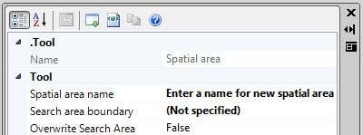 Spatial Areas – The screen shot adjacent shows the ASD Spatial Area tool allowing the user to select a polygon along with a name to be associated with it. The boundary is then stored in the database referenced by its name. A key point here is that the boundary is stored as a series of geographical coordinates which then allows for spatial query to obtain terrain points. ASD has developed a database schema, called AeroDataStore, to handle the terrain data which uses Microsoft database technology of SQL Server and SQL Database. These offer a scalable solution which is needed when handling large amounts of terrain data; typically millions of points to handle fast query times.
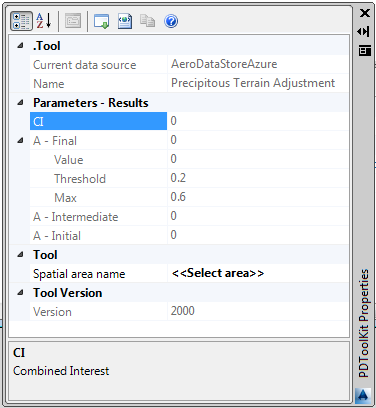
Precipitous Analysis Calculation – A series of equations is used to derive the Combined Interest (CI) value and then this is used with a piecewise function to get an adjustment value; this adjustment can be different for the Final and Intermediate segments of the procedure. There are five equations calculating:
g(1) – Average Elevation
g(2) – 98th percentile – 2nd percentile height differential
g(3) – Slope Gradient
g(4) – Standard deviation from plane of best fit
g(5) – 98th percentile maximum – minimum height differential on tiles
On the screen shot (to the right) the full set of values can be seen for the calculation of a possible adjustment. At the top the CI and the adjustment values are shown with the results of the 5 equations g(1) to g(5) along with the Interests and Weights used. Further details can be obtained from the FAA regarding the complete equation set.
The PDToolKit Precipitous Terrain Analysis module is now available for $5,000. Please contact us at mailto:[email protected] for more information.