Airports are magnets for business and growth and hence usually attract a great deal of property development. The continually changing landscape both outside and inside of the perimeter fence creates a challenge for those tasked with AEROSafeGuard, with a continuous stream of requests to evaluate new and proposed obstacles against protection surfaces. These requests are usually handled by specialist teams who operate sophisticated CAD/GIS tools (such as ASD AEROSafeGuard or PDToolKit) and have access to the protection surfaces required.
AEROSafeGuard is a cloud service that enables non specialists to quickly and easily create obstacle assessments from any location using nothing more complicated than a web browser and an internet connection.
Creating Obstacles
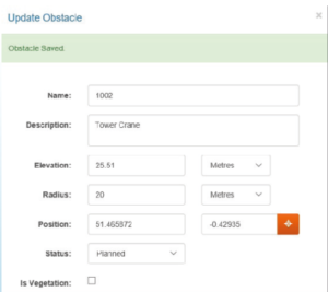
Entering a new obstacle is simple. All you need to know is the basics: how big it is and where it is. Use the simple entry form show below to name and describe your obstacle. Provide the elevation (above Mean Sea Level) of the highest point on it and a radius to represent the objects physical extent. The position can be provided in two ways. If you have an accurately surveyed location, you can input the latitude and longitude. If you don’t, then you can click on the map view and define an approximate location.
Obstacles are grouped into Assessments. An assessment is just a bucket of obstacles that will all be processed together and their assessment results delivered in a single report. Users may organise assessments however they wish.
Assessment Results
With several obstacles grouped into an assessment, we can ask Aerodrome Surface Assessor to do its analysis. AEROSafeGuard takes each obstacle in turn and calculates if it penetrates any of the surfaces that have been loaded into the system.
After a few minutes the assessment result is displayed as shown below. The user can clearly see which obstacles penetrate, by how much they penetrate and for which surfaces the infringement occurs.
Note that, as well as green (no penetration) and red (penetrates) there is also yellow to indicate near penetrations. Each assessment may have a tolerance applied to provide for an extra margin of safety.
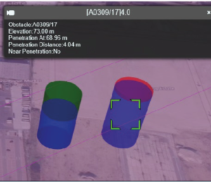
As well as obtaining a simple tabular report, which can be printed or emailed, AEROSafeGuard also enables the obstacles with penetrations to be shown against a map with the protection surfaces shown as transparent overlays. In the image below, the obstacle on the left does not penetrate the surface and the green part of the cylinder indicates how far below the surface the obstacle is. The obstacle on the right does penetrate, and the red part of the cylinder indicates by how much. The precise distances are given in the tabular report shown above.
What surface data is required?
Aerodrome Surface Assessor can work with any type of surface, but the most commonly used are Annex 14 Obstacle Limitation Surfaces and IFP Obstacle Assessment Surfaces.
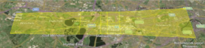
ASD can provide the software tools required to produce these surfaces or create them for the user if they wish. If the surfaces already exist, we will assist the user in getting their data into Aerodrome Surface Assessor. An Annex 14 Obstacle Limitation Surface for a runway (as generated by Surface Modeller) is shown below.
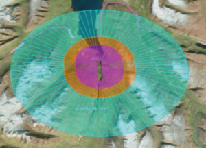
An ILS Obstacle Assessment Surface (as generated by Surface Modeller) is shown below. Any surface generated by Surface Modeller can be imported into Aerodrome Surface Assessor for use in assessments.
Aerodrome Surface Assessor is provided as an online Cloud based service and is fully managed and maintained by ASD. It can be made available to an organisation’s internal users and may also be provided in a customised form for external use. ASD are always happy to discuss a customers’ specific needs.